


Geotagging+

Descrizione di Geotagging+
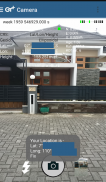
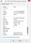
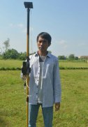
This app allows you to take image and measure with low-cost GNSS module (like U-blox GNSS module or E-GNSS from potretudara : http://www.potretudara.com/low-cost-gps-gis/ ). Measured coordinates from low-cost GNSS module are stored to EXIF image metadata in time when you tap the "capture" button. Use this to create your geotagging more precise to sub-meter level. Very useful for census, GIS support, reporting issue, and others.
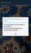
You can still use internal GNSS for geotagging by deactivate BASE and ROVER in the Input Stream menu. Obviously none of the precision algorithm found in RTKLIB can be use.
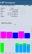
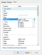
Image taken by this app will have coordinate metadata, accuracy, and solution type (internal, single, float, or fix).
Heavily based on RtkGps+ from Ronan LE MEILLAT, this is a fork of his work. Original licenses are in the "About/Legacy Info" screen. Thanks to all contributors to respect this clause.
This app is RTKGPS+-like with additional Camera menu. You still can use this app for surveying, tracking, etc. like RTKGPS+ do.
This app is a port of RTKLIB 2.4.3b 28 developed by Tomoji Takasu (http://http://www.rtklib.com/). This RTKLIB 2.4.3 is modified by rtklibexplorer and named RTKLIB 2.4.3 demo 5 b 28 (https://github.com/rtklibexplorer/RTKLIB). If you do not know what this application is, this application is probably not what you are looking for!
App manual : http://bit.ly/shortmanual
Questa applicazione consente di scattare immagini e misurare con il modulo GNSS a basso costo (come modulo GNSS U-blox o E-GNSS da potretudara: http://www.potretudara.com/low-cost-gps-gis/). coordinate misurate dal modulo GNSS a basso costo vengono memorizzate per metadati EXIF dell'immagine in tempo quando si tocca il tasto "cattura". Usare questo per creare il geotagging più precisa al livello sub-metro. Molto utile per censimento, il supporto GIS, tema di reporting, e altri.
È comunque possibile utilizzare GNSS interno per geotagging da BASE disattivare e ROVER nel menu flusso di input. Ovviamente nessuno dell'algoritmo di precisione si trovano in RTKLIB può essere utilizzato.
Immagine presa da questa applicazione avrà coordinate metadati, la precisione e tipo di soluzione (interno, singolo, galleggiante, o correzione).
Pesantemente sulla base RtkGps + da Ronan LE MEILLAT, questo è un fork del suo lavoro. licenze originali sono nella schermata "Informazioni / Legacy Info". Grazie a tutti i collaboratori di rispettare questa clausola.
Questa applicazione è RTKGPS + -come con menu Fotocamera supplementare. È comunque possibile utilizzare questa applicazione per la rilevazione, il monitoraggio, ecc come RTKGPS + DO.
Questa applicazione è un porto di RTKLIB 2.4.3b 28 sviluppato da Tomoji Takasu (http: // http: //www.rtklib.com/). Questo RTKLIB 2.4.3 viene modificato da rtklibexplorer e nominato RTKLIB 2.4.3 demo 5 b 28 (https://github.com/rtklibexplorer/RTKLIB). Se non sapete cosa questa applicazione è, questa applicazione non è probabilmente quello che stai cercando!
Manuale App: http://bit.ly/shortmanual


